“On the Trail of Henry Knox” by Jennifer Dorsen (Part 4 of 5)
4. In which I Deep Dive into Past Research and Talk to More Experts
Returning to Somerville, my research began in earnest. A few researchers and I created a Google Sheet to enter every book, article and resource we reviewed along with the result: did it mention Cobble Hill, cannons, the Knox cannons, or cannons ON Cobble Hill? On secondary sources, we made sure to follow up any footnotes, adding new documents as we went. To date, we have read through 36 books and articles, checked information on over 20 wiki pages and consulted with about 5 experts on Knox, the War and cannons.
There are lots of ways to explore Knox topics, and for those who want to travel the state for special events will find happenings in Great Barrington, Springfield, Worcester, and Roxbury among others. Cambridge will do a larger event on February 28th, and Boston is pulling out all the stops for Patriots’ Day this year! Check the Revolution 250 website for specifics.
It is an opportunity to review and refine our understanding of these events with new eyes. For example, Ben Haley of the Massachusetts Historical Commission has been researching Knox’s route in western Massachusetts to identify the exact path of the Noble Train. When markers were put up in 1926, some liberty was taken with the locations. The commemorative committee put the markers in publicly accessible areas, so he is searching for the actual path.
My own research was in a race against time - I had hoped to find those cannons by the anniversary of the Noble Train. Instead I was learning more about how one small area of today’s Somerville (recall the area was Charlestown back in the day) played a part in the Revolutionary War.
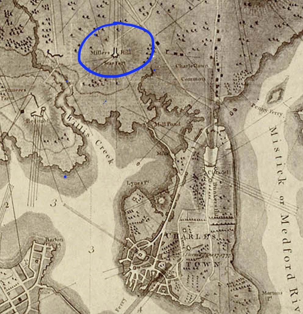
MHS Collections Online: A Plan of Boston in New England with its Environs, including Milton, Dorchester, Roxbury, Brooklin [sic], Cambridge, Medford, Charlestown, Parts of Malden and Chelsea, with the Military Works Constructed in those Places in the Years 1775 and 1776
Viewed at https://www.masshist.org/database/viewer.php?item_id=2052&mode=large&img_step=1&&pid=3&ft=Object of the Month&nodesc=1
We know that Cobble Hill was the site of Star Fort though we have few historical documents. One detailed map shows it, labeled as sitting on Miller’s Hill, an alternate name. We can look at schematics and plans that show the shape and design in a star formation, commonly used in the 18th century for its defensive properties. We know that General Nathaniel Greene oversaw this fort along with those at Prospect Hill and Winter Hill, with at times 4000 soldiers stationed there. It seems they rotated among the three forts. And we know that by December a large cannon nicknamed the Congress was positioned there. (“The Congress” was as common a name for large cannons as “Spot” is for little dogs.) It was taken from a captured British war vessel and moved to Cobble Hill. It saw a bit of action prior to March, 1776 as documents report scattered small events - a cannon shot here or there, for example - over the winter months. Given that they had one cannon there, and the technical knowledge to fire it, were other cannons added when Knox brought his bounty to the Boston Basin?
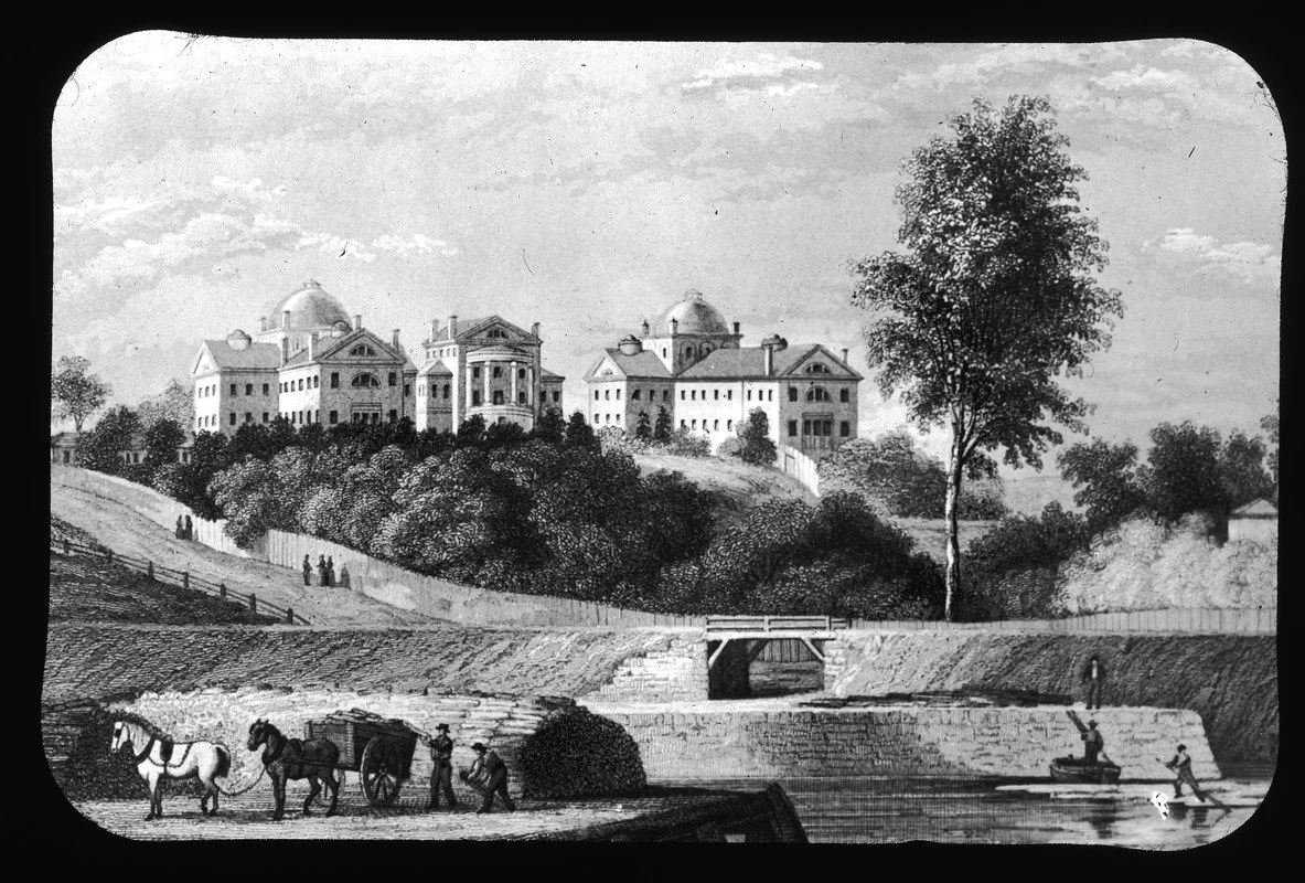
McLean Asylum. Opened Oct. 6, 1818, on Miller's or Cobble Hill, which had been a highly important fortified position in winter of 1775. The hill has now been almost removed for the B. & M. R.R. freight switchyard or "hump." Named for honored merchant, John McLean. Viewed at:
https://www.digitalcommonwealth.org/search/commonwealth:8k71p270v
I contacted McLean’s Hospital’s archivist for additional information about Cobble Hill. In 1793, after the war, Cobble Hill became the site of the Barrell mansion, a grand “summer” house of the Barrell family whose money came from shipping and fisheries. Although they lived in Boston, the family acquired this land for their larger summer house, a short paddle across the Charles River. In 1811, it was sold to the McLean Asylum as a hospital for those suffering mental illnesses. When the area became built up, especially with noisy, smoke-belching railroads, McLean’s moved to Belmont, and the house was eventually torn down. The grand central staircase, however, was preserved and is now at the Somerville Museum. The archivist at McLean’s has architectural drawings of the house, but no information on its prior life in War. The Hill itself was razed for fill after 1914.
Could I find any evidence of the battles (or even the hill) at today’s Cobble Hill? I walked around the area with Wig Zamore, a Somerville expert on land use change. We wanted to find evidence of the Hill, of what it might have been 250 years ago. We had the 1852 Draper Map that showed the first railroad lines of the area. It is known that roads - rail or otherwise - often get put down early in a city’s life and are the hardest to change. These rail lines were great examples! The map showed the rail lines that are still there! One can easily match the current rail with those on the map and loosely determine where the house was, and therefore the highest point where the Star Fort sat.
Three quarters of a mile away is Prospect Hill, and visiting there reminded me that it was THE best location to understand the war with the entire Boston basin visible at a glance including two rivers, Boston proper, the harbor and numerous towns. It is unclear if any cannons were positioned there, but it was quite a bit higher than it is now, and might not have had a suitable location on its steep southern side facing Boston.
To find more clues we would need to visit the archives.